Friday, August 25, 2017

Hurricane Harvey

This is not exactly relevant to Chicago, but given the potential for airport disruption all over the country -- especially here, given United’s hub in Houston and Southwest’s presence all over Texas* -- I thought I’d send a quick note. Anyone in the region should pay close attention and follow any evacuation orders.


Harvey is currently offshore and still strengthening. This has turned into a serious situation that is going to endanger many lives and cause massive property destruction. Sustained winds are 110 mph with a minimum central pressure of 950 MB (28.05 inches), both well into Category 3 (major) hurricane territory. Conditions have been almost perfect for strengthening so far, and even if it levels off there may be little to stop it before a landfall on the Texas coast late tonight or early Saturday morning. As of now, the odds are better than even that Harvey will be a Category 3 (major) hurricane at landfall. If so that would be the first major hurricane to make landfall in the U.S. since Wilma in 2005.


The potential for catastrophic storm surge along the coast is a huge concern. NWS/NOAA is calling the threat to life and property “extreme” with near total coastal devastation from a 7-11 foot surge. And of course the wind damage from gusts in the 100-125 mph range is a major hazard as well.


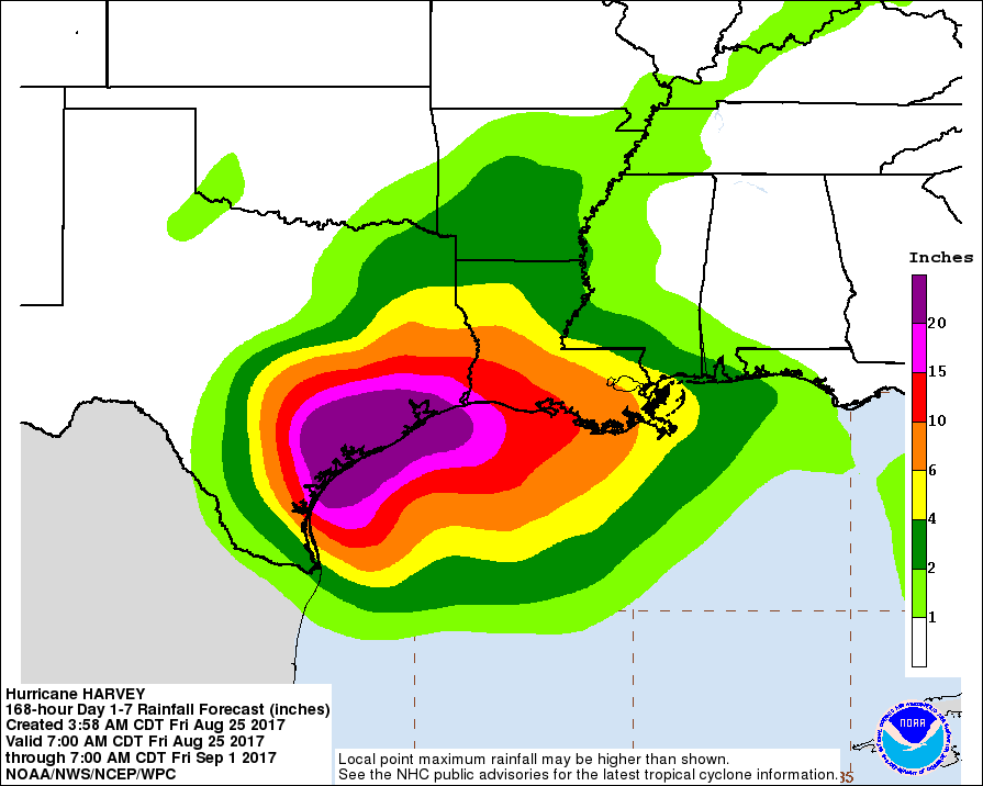
Away from the coast the rainfall this storm could produce is incredible. Because the storm is moving very slowly – and because it may come close to stalling after landfall, as many Texas tropical storms do – the flood potential is off the charts. Most models are putting the multi-day rainfall totals in the 15-20 inch range for metro Houston, with totals between two and three feet closer to the coast (including Galveston). Even places as far as San Antonio and SW Louisiana could see 6-12 inches of rain. The precise strength/wind at landfall is hard to pinpoint, but this storm is coming ashore and the disastrous rainfall is all but assured.


* United already started waiving all change fees yesterday, and other airlines will likely follow suit. Systemwide delays and cancellations are still probable.


This email is confidential and intended only for the recipient(s). If you have received this message in error, please notify the sender at compliance@anabaticllc.com and delete this message and any attachments. This message is provided for informational purposes only and should not be construed as a solicitation or offer to buy any financial instruments. Please see the full disclaimer at www.anabaticllc.com.


Sunday, July 23, 2017

Severe tstorm warning

A strong storm is blowing up and currently severe warned. 60-65 mph gusts with large hail. Over central Dupage and heading SE. Worth watching in the area. Northern burbs already having some storms and soon the city will see them too.

Friday, July 21, 2017

Enhanced severe threat tonight

The whole area is under an "Enhanced" threat of severe storms. The main storms will be through between 8pm and 2am but other storms ahead of and behind the main line are also possible. Damaging winds are the main threat but the whole area could also see 1-3" of rain, exacerbating the flooding in northern areas.

(I'm also out of town for a wedding so no more updates tonight even though this is one to watch.)

Wednesday, July 19, 2017

Severe tstorm watch

The whole area is under a severe thunderstorm watch until midnight. There is a line of very strong storms crossing from Minnesota and Iowa into to northern Illinois and current conditions there are rough. Gusts well above 70 mph have done damage to buildings and trees. These storms should weaken as they approach our area, but high winds and heavy rain with lightning are still possible as we get toward the 9pm-midnight range. More storms may develop and linger into tomorrow morning. There will also be off-and-on storms through Saturday.

Wednesday, June 28, 2017

Re: Tornado Watch

Tornado warning for a storm moving east of Rockford. Strong rotation on radar but unconfirmed tornado. That line will move across a line from Elgin to Buffalo Grove to Evanston from roughly 8:30 onward. Worth paying close attention to that one. Also a tornado warning across the state line in Wisconsin. Main severe/tornado threat remains north of I-88 and especially favors northern Cook into Lake. 

On Jun 28, 2017, at 7:26 PM, Philip C. Ordway <pordway@anabaticllc.com> wrote:

A tornado watch was just issued for the entire city and almost all suburbs until midnight. Conditions ripened to our west and several damaging tornadoes have affected Iowa. That complex will come through the area from roughly 8:30 to midnight. The most favored areas will be north, especially near the WI line, but conditions overall are marginal. That said, severe storms and tornadoes are possible and these storms bear watching. (I will be on an airplane and unable to pay much attention.)

More storms will sporadically roam the area tomorrow (especially in the morning) and Friday before clearing out for most/all of the weekend. Temps will be seasonable with highs in the 80s.
-------------------------------------------------------------------------------------------------------------------------------------------------------------------------------- This email is confidential and intended only for the recipient(s). If you have received this message in error, please notify the sender at compliance@anabaticllc.com and delete this message and any attachments. This message is provided for informational purposes only and should not be construed as a solicitation or offer to buy any financial instruments. Please see the full disclaimer at www.anabaticllc.com.


This email was sent to pcordway@gmail.com
why did I get this?    unsubscribe from this list    update subscription preferences
N/a · N/A · Chicago, IL 60606 · USA

Email Marketing Powered by MailChimp

Tornado Watch

A tornado watch was just issued for the entire city and almost all suburbs until midnight. Conditions ripened to our west and several damaging tornadoes have affected Iowa. That complex will come through the area from roughly 8:30 to midnight. The most favored areas will be north, especially near the WI line, but conditions overall are marginal. That said, severe storms and tornadoes are possible and these storms bear watching. (I will be on an airplane and unable to pay much attention.)

More storms will sporadically roam the area tomorrow (especially in the morning) and Friday before clearing out for most/all of the weekend. Temps will be seasonable with highs in the 80s.
-------------------------------------------------------------------------------------------------------------------------------------------------------------------------------- This email is confidential and intended only for the recipient(s). If you have received this message in error, please notify the sender at compliance@anabaticllc.com and delete this message and any attachments. This message is provided for informational purposes only and should not be construed as a solicitation or offer to buy any financial instruments. Please see the full disclaimer at www.anabaticllc.com.

Friday, June 16, 2017

Enhanced severe storm threat tomorrow (Saturday)

Another hot day today will yield to more overnight storms before another hot day builds on Saturday. The high temps on Saturday will likely approach or cross 90F in many places despite some lingering clouds and showers in the morning. Dewpoints will also be in muggy-territory – approaching 70F. And by late afternoon or early evening on Saturday and approaching cold front will bring a good chance for severe storms. We’re in the “Enhanced” region per SPC (see below) which is a strong indicator. I wouldn’t cancel any plans, and most of the daylight hours should be safe. By anything past 3-4pm deserves a close eye.


-------------------------------------------------------------------------------------------------------------------------------------------------------------------------------- This email is confidential and intended only for the recipient(s). If you have received this message in error, please notify the sender at compliance@anabaticllc.com and delete this message and any attachments. This message is provided for informational purposes only and should not be construed as a solicitation or offer to buy any financial instruments. Please see the full disclaimer at www.anabaticllc.com.