Friday, April 28, 2017

heavy rain threat

Just a quick note to highlight the chance we have for very heavy rain totals over the weekend. Showers will remain very light and spotty in coverage tonight and through noon tomorrow.


Saturday morning could be mostly dry, but from early afternoon tomorrow through the evening some heavy rain will develop and move into the area.


Sunday looks especially wet. And storm totals through Sunday night or Monday morning could be extreme – 2 inches of rain looks likely and some areas could well see 4 or even 5 inches of rain. Localized flooding is possible or even likely.


This email is confidential and intended only for the recipient(s). If you have received this message in error, please notify the sender at compliance@anabaticllc.com and delete this message and any attachments. This message is provided for informational purposes only and should not be construed as a solicitation or offer to buy any financial instruments. Please see the full disclaimer at www.anabaticllc.com.

Monday, April 10, 2017

Severe T-storm Watch is likely

Just a quick update about the threat for severe storms this afternoon. We’re not currently under a watch, but one is likely in the entire area (see below). It is unlikely that any of these individual storms will merit a separate update, but be on the lookout for locally severe storms this afternoon. The most likely window is 2-5pm, with the usual caveats about timing/predicting something like an individual thunderstorm. The usual high-wind threat is there but there is also an unusually high potential for large hail with these storms.


The good news is that while the air traffic backup could be a problem that lingers all day, the storms should clear near or in time for rush hour and the Cubs game.


In other news, our mid-range outlook is mild and mostly dry.


This email is confidential and intended only for the recipient(s). If you have received this message in error, please notify the sender at compliance@anabaticllc.com and delete this message and any attachments. This message is provided for informational purposes only and should not be construed as a solicitation or offer to buy any financial instruments. Please see the full disclaimer at www.anabaticllc.com.

Monday, March 13, 2017

Lake-Effect Snow Warning

Sorry, one last update. After >1-2” snow totals from the passing system we’ve been upgraded to a Lake-Effect Snow Warning tonight at 7pm through tomorrow afternoon for Cook, Lake and DuPage. The storm that has just passed us is really intensifying (see below) and that is going to pull cold air across the open water of Lake Michigan and right into Chicago. Favored locations in Lake and northern Cook could easily 6-8” or more of additional, and most of the area will see at least another inch or two.


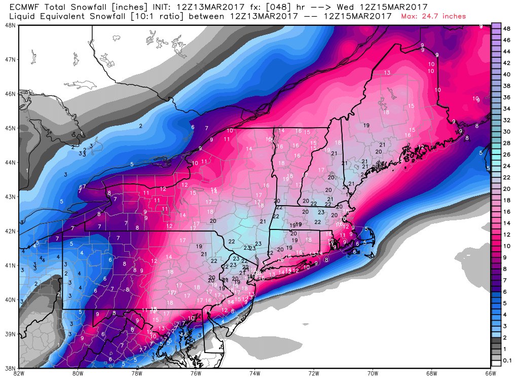
And our storm is going to explode on the East Coast. It’s not quite “March 1993 Superstorm” level but it’s still very impressive. The entire NJ/NY/CT/New York City area is under a Blizzard Warning – winds could easily hit 60-70 mph in Manhattan with over a foot of snow. DC might get “missed” with 3-6” of slushy mix, but things escalate just to the north and west with a band of 10-inch to two-foot snow totals likely throughout the NE corridor and New England. Even if any of several factors cut the snow totals slightly the incredible strong winds are a lock and will leave quite an impression.


American Airlines just cancelled every single flight to/from LGA and JFK for the entire day tomorrow, and other airlines will likely do the same. All travel from DC to Philly to NYC to Boston is going to be a joke tomorrow, and it may take a day or two to recover.


This email is confidential and intended only for the recipient(s). If you have received this message in error, please notify the sender at compliance@anabaticllc.com and delete this message and any attachments. This message is provided for informational purposes only and should not be construed as a solicitation or offer to buy any financial instruments. Please see the full disclaimer at www.anabaticllc.com.

Sunday, March 12, 2017

last snow update

Not much change to the overall picture. Snow has started to fly in the far N and W suburbs and will overspread the area in the next hour or two. Most locations will see 1-3” by morning and another 1-4” during the day tomorrow. Favored lake-enhanced areas may see totals creep above 6-8” by Tuesday morning. One note about the snow totals, though – it’s going to be a pretty wet snow and temps will be in the low 30s so snow should compact and melt pretty quickly. Snowfall rates will also be light/moderate and roads that are (pre)treated should be wet, but I would still expect some travel delays tomorrow.


The East Coast, meanwhile, is in for a major storm. It’s impossible to get the details right, but at this point if you needed a textbook model of a powerhouse Nor’easter this would be eat. The entire DC-BWI-PHL-NYC-BOS corridor is in the bullseye for a huge snow. The entire region is under a Blizzard and/or Winter Storm Watch. The over-under on snow in NYC is trending over a foot and about 14” in Boston.


This email is confidential and intended only for the recipient(s). If you have received this message in error, please notify the sender at compliance@anabaticllc.com and delete this message and any attachments. This message is provided for informational purposes only and should not be construed as a solicitation or offer to buy any financial instruments. Please see the full disclaimer at www.anabaticllc.com.

snow update -- WWA here, major disruptions (WSW/Blizzard) elsewhere

Cold temps and a potent disturbance are coming together to create a pretty strong late-winter storm. The cold has gone far enough south to create sticking snow this morning in Charlotte, NC and Augusta, GA! That is just the prelude, though -- Winter Storm Watches and Blizzard Watches are up for areas to our west and north as well as much of the Northeast Corridor. The entire Chicago area is under a Winter Weather Advisory for 3-6” of snow. At least 2” of sticking snow looks likely for the entire area, and in favored areas (far W/NW and along lake) up to 8” is possible. This is also all but assured to snap our streak of days without 1” of snow at 85 or 86 days. (I believe the all-time record is 87, which is a shame.)


This is going to be a fairly long duration snow given the size and scope of the low. Despite the beautiful sunshine this morning an overcast will develop quickly by late morning or early afternoon and snow could be flying by early evening. Moderate snow could fall off and on tonight with considerable snow tomorrow morning. As the low moves east the backside NE flow could add some lake-effect through Tuesday morning.


Travel disruptions should be expected tomorrow – roads and airports will be slow for the morning rush, if not beyond.


The meat of the storm will pass through the MSP area and the Mississippi Valley into Wisconsin before swinging east. 4-8” of snow, if not more, looks likely there. And the real problem looms on the East Coast. The track of the low, as always, is tough to pinpoint, but the best guess we have right points to a very potent storm tracking the coast in the favored location for heavy snow. Large portion of the NYC and New England population centers are under Blizzard Watches and the rest are under Winter Storm Watches. 4-6” in DC quickly trends toward a foot or more from NJ through NYC into NE/Boston. Right now the 50% probability is for a foot of snow right through the NYC-CT-Boston corridor, and one good model is leaning toward 14-16” or more. This far into March it would normally be hard to draw enough cold air into the storm, but it s 9-degrees in Boston this morning, so that problem has already been solved. Major travel disruptions are likely from Monday night through most/all of Tuesday.  


This email is confidential and intended only for the recipient(s). If you have received this message in error, please notify the sender at compliance@anabaticllc.com and delete this message and any attachments. This message is provided for informational purposes only and should not be construed as a solicitation or offer to buy any financial instruments. Please see the full disclaimer at www.anabaticllc.com.

Friday, March 10, 2017

Snow?

Winter isn’t quite done yet – in a special dose of irony, it looks likely that for the first time ever we will have a snowier March than the preceding January and February combined.


Other areas (see below) are going to get it worse, but starting Sunday night and lasting through some or most of the day Monday we’re likely to see a few inches of wet snow. Details are too hazy to pinpoint, but anywhere from a slushy covering to 3-4” look possible at this point. The ground is obviously very warm and hopefully the roads will be treated, but I would still expect some travel problems (especially on the Monday morning commute).


Beyond Tuesday/Wednesday the pattern will flip and we’re likely to be well above average (i.e., 50s and maybe 60s) by the following weekend.


In the meantime, our snow on Sunday/Monday could be a much bigger deal to our south and west, and once it moves east it could develop into a potent nor’easter.  The track is too uncertain for the DC-NYC-Boston corridor, but it could be anything from a vicious, driving rain with 40-50 mph winds or a major snowstorm. 2-6” in DC to well over a foot in NYC/Boston are possible in the latter scenario. Travel disruption looks very likely Monday/Tuesday across the entire Northeast.


This email is confidential and intended only for the recipient(s). If you have received this message in error, please notify the sender at compliance@anabaticllc.com and delete this message and any attachments. This message is provided for informational purposes only and should not be construed as a solicitation or offer to buy any financial instruments. Please see the full disclaimer at www.anabaticllc.com.

Monday, March 6, 2017

severe threat tonight

After missing last week’s storms I’m trying to make up for it, especially since there is a decent threat of a repeat late tonight. Today’s gusty winds in advance of a cold front will feed approaching storms between 10pm and 2am. We’re on the far NE corner of an area outlooked for severe weather, as depicted by one model shown below. Brief downpours and damaging winds are possible. Even if we get severe-warned, though, I’m hoping to sleep through this one.


Tomorrow should be windy but sunny and mild. Beyond that we’re likely to settle into a wet and chilly period. We’re going to sit on the southern edge of some cold air, and a couple of bouts of passing rain or snow look likely from late week through early next week. Some snow is possible, and it wouldn’t take much for March to end up snowier than January and February combined! Barring the unexpected development of a major storm, any snow would likely be limited to a few inches and be gone within a day or two. The pattern looks likely to flip to a milder one by mid-/late-month.


This email is confidential and intended only for the recipient(s). If you have received this message in error, please notify the sender at compliance@anabaticllc.com and delete this message and any attachments. This message is provided for informational purposes only and should not be construed as a solicitation or offer to buy any financial instruments. Please see the full disclaimer at www.anabaticllc.com.