Since there are a few new emails on the list and it has been months since anything has happened here, I’ll take this chance to answer some of the questions I’ve been getting about Hurricane Matthew. This is turning into a very serious situation for Florida – easily one of its most dangerous and costly hurricane threats in modern history.
· Matthew is currently a Category 4 storm with sustained winds of 140 mph. Gusts have been measured over 160 mph. Those winds will do catastrophic damage if they don’t stay offshore (see below). Anyone near the coast should not mess around with this hurricane.
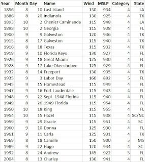
o A Category 4 hurricane making landfall is very rare. (One has never been recorded in the section of Florida where this storm is headed.) If the storm makes landfall at this strength it would go down as one of the 20 strongest landfalling hurricanes ever seen in the U.S. and likely one of the 5-10 costliest (into the tens-of-billions range). The current minimum central pressure of 938 mb is extreme and already puts it in the all-time ranks alongside storms like Hurricanes Charley and Hugo.
· Matthew’s overall track is pretty well set now, but the details will be all important and are almost impossible to pinpoint in advance. The difference of 5-10 miles (on a storm that is ~700 miles wide with hurricane-force winds in a ~65 mile radius) could mean some damage up to total destruction.
o Matthew will approach the east coast of Florida tonight and make landfall (or come very close to it), likely somewhere north of West Palm Beach to near Jacksonville. It could grind along the entire east coast of Florida.
§ Jacksonville in particular is looking very vulnerable to the surge. The local NWS office in conjunction with NHC is calling for “catastrophic damage” in a “worst-case scenario” for costal areas
o If the storm wobbles just 10-20 miles to the west, the core of the strongest winds will cause heavy damage.
§ The latest run of a popular model has again taken the storm west, with a major Cat. 4 hurricane making direct landfall into Brevard County. Let’s hope that is wrong. Yes, the models got it mostly wrong earlier this week when most had it staying well east over open water. Now we’re in much different circumstances. If the track can stay just a few miles east it will make a huge difference. But it is not looking good.
o Even if the eye stays slightly out to sea, areas along the coast to several dozen miles inland will see hurricane-force winds (≥100+ mph very easily) and significant structural damage.
o Coastal areas will see a storm surge of 3-6+ feet.
o Most areas will see 4-12+ inches of rain.
· It has been over a decade since a significant hurricane hit Florida (an unprecedented stretch in recorded history).
· Dangerous hurricane or near-hurricane conditions will continue into Friday and Saturday for the Georgia and South Carolina coasts.
· Matthew made end up making a loop, doubling back on itself toward the south, off the SC coast.


No comments:
Post a Comment